Feb. 12, 2022
New Minor in Software Engineering

‘The Software Engineering minor program offers a unique opportunity for the Schulich School of Engineering to become a national and international leader in the transformation of geomatics engineering education. It also looks to open new pathways in research and in the profession for future graduates of the program.’
Geomatics Engineering at UCalgary
Geomatics engineering is one of the fastest growing information technology disciplines. The foundation of geomatics engineering lies in the “science of location,” i.e., the science of digital transformation, the science of exploration and navigation, the science of commerce and ecology.
Since its inception in 1979, the department of Geomatics Engineering at the University of Calgary has been a world leader in education and research of the cutting-edge technologies in geospatial data acquisition (GPS, 3D imaging and earth observation systems, drones and UAVs, geosensors and IoT) and handling (big data analytics, machine/deep learning, web services for mapping, and geovisualization).

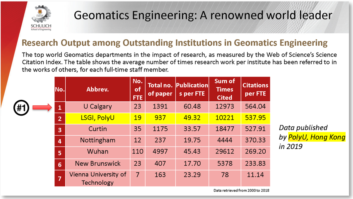
The Department of Geomatics Engineering at UCalgary was ranked 1st by the PolyU, Hong Kong in 2019.
Geomatics Engineering is Ubiquitous
Today, Geomatics Engineering technologies are ubiquitous and naturally connected to almost all disciplines in science and engineering for those looking to expand their horizons.
The most popular device, our mobile phone has a GPS receiver that feeds a plethora of Apps with our instant location to help us navigate in space, find our friends, geotag our photos, or measure our physical activity. New phones are now equipped with LiDAR cameras, another geomatics technology that works in a similar way to radar, only it uses lasers, to enhance our photos with distance and depth information.
Geomatics technologies are present in every human activity you may think of; including intelligent transportation and autonomous vehicles, smart cities, natural disaster management, environment and climate change adaptation, mineral extraction, archaeology and history, biology and medicine, oceanography, and space exploration.
Diverse geomatics engineering applications (from, left to right): (i) The Mars exploration rovers have travelled to and landed on Mars successfully thanks to geomatics technologies; (ii) The COVID-19 dashboard from the Johns Hopkins Center for Systems Science and Engineering: Geosensors, IoT and mapping systems have been priceless tools in monitoring the spread and prevention of the Covid-19 pandemic. (iii) Countless geomatics engineering technologies have been used to construct the venues and record the athletes’ performance with the finest accuracy in sports events such as the Olympic Games (sport velocity-tracking device) or the FIFA World Cup (heatmap visualization); and (iv) Multi-sensor systems: Self-Driving Cars and navigation sensors.
The Software Engineering Minor
‘The growing needs for advanced software engineering approaches in geospatial data handling has led to the creation of the software engineering minor.’
With billions of devices connected to the Internet of Things (IoT) and the earth observation systems mounted on satellites, aircrafts and UAVs, executives and decision-makers have access to unprecedented amounts of geospatial data. A growing challenge for geomatics engineers is to build “location intelligence” by processing, analyzing, and visualizing massive volumes of geospatial data to empower holistic planning, prediction and problem solving.
To meet this challenge and address the high industry demand, the geomatics engineering major program is now enhanced with a minor in Software Engineering. Working together with the Department of Electrical and Software Engineering, a series of software engineering courses were added in the new minor with the goal of making students more well-rounded. Subjects like software design and development, data science, artificial intelligence (AI) and machine learning (ML), and geosensors and internet of things (IoT), are included in the new minor. The new minor is meant to rescale our undergraduate program curriculum, open new employment opportunities for our students, and enhance the multi-disciplinary collaboration within the Schulich School of Engineering.
‘The proposed Minor in Software Engineering seeks to bring a distinct understanding of software engineering knowledge (and associated skillset) to students in the geomatics engineering major.’
Courses in the Software Engineering minor:
‘The software engineering minor will be available to all students placed in Geomatics Engineering, starting in the 2022 Fall Term.’
The BSc in Geomatics Engineering with the minor in Software Engineering is a 4-year program, with an even distribution of courses over the upper three years of study (12 courses per year or 6 courses/term in the fall and winter). Students have the option to select courses from a wide pool of available offerings, based on their academic interest. Additionally, some key courses are also offered in the spring and summer terms – allowing students to redistribute their yearly course load across 3 or 4 terms, instead of 2 terms.
Mandatory courses:
- ENSF 300 Software Engineering Practices for Data Management
- ENGO 333 Computing for Geomatics Engineers
- ENSF 409 Principles of Software Development
- ENSF 480 Principles of Software Design
- ENSF 444 Machine Learning Systems
- ENGO 535 Spatial Databases and Data Mining
- ENGO 551 Advanced Geospatial Topis (Geospatial Web, Geosensors and IoT)
- ENGO 500 Geomatics/Software Engineering Project
Optional courses:
- ENSF 544 Data Science for Software Engineers
- ENSF 545 Introduction to Virtual Reality
- SENG 513 Web-based Systems
- ENEL 573 Computer Networks
- ENEL 563 Biomedical Signal Analysis
- ENCM 517 Computer Arithmetic and Computational Complexity
- ENCM 563 Fundamentals of Biometric Systems Design
- ENGO 531 Advanced Photogrammetric and Ranging Techniques
- ENGO 545 Hydrographic Surveying
- ENGO 559 Digital Imaging and Applications
- ENGO 563 Data Analysis in Engineering
- ENGO 585 Wireless Location
Employment opportunities
The Geomatics Engineering department at the University of Calgary offers unique employment prospects for graduates in the thriving and growing geomatics and software industry. Our alumni have worked for successful giant, mid-size, and startup companies and governments in Alberta, Canada and beyond:
For more information on Geomatics Engineering major, the new Minor in Software Engineering, or any other questions about your engineering future, contact the Engineering Student Centre at engginfo@ucalgary.ca.
